An MBA student from the University of Northampton has become a business entrepreneur, launching the UK’s first commercial hub for drone operators.
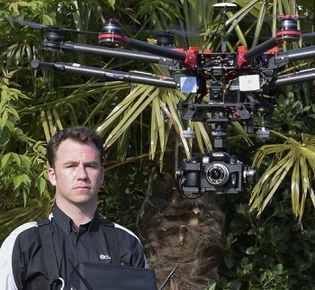
Richard Gill, aged 34, completed the Masters of Business Administration this year via distance learning. Before undertaking his MBA he worked for the Army, and the new venture, Ocuair Ltd, has been set up with a former colleague.
Richard explained the inspiration behind Ocuair Ltd: “Drones are becoming more common in the skies across the UK; indeed, there isn’t a property or CountryFile television show that doesn’t have a number of clips captured from a drone.”
The drone service produces ultra-high resolution aerial maps of a far superior quality to very best commercially available aerial maps, and Ocuair Ltd is offering something different to the competition. Richard explains: “We had heard complaints from building surveyors and other aerial map users about the quality and accuracy of the current commercially available aerial mapping products, so we set out to see how we could find a solution. That’s how we came up with Aerial Map Market.”
Richard continued: “The service is designed to be a simple as possible. If you need a map you simply log into your account and draw the area you want mapping. We check for any safety issues and agree a set fee, and one of our growing team of certified and accredited operators will complete the mapping process and deliver the results in days.”
While starting his business, Richard had the support of the University and his programme leader Dr Mills Hills from Northampton Business School.
Dr Hills said: “One of the most rewarding and fascinating parts of our job is seeing students combine their prior learning with academic concepts and rigour to produce business success. In Richard’s case, Ocuair is defining standards of quality and value for UAV (Unmanned Aerial Vehicle) imagery and introducing innovation into an emerging market, thereby helping customers and similarly-minded providers alike. It’s an inspiring story – and I look forward to hearing great things about Ocuair and its Aerial Map Market.”
Richard commented: “The University of Northampton course was fantastic and reinforced my previous business and management studies. Now in my new life, my MBA qualification not only gives me more credibility in the eyes of my clients but it has taught me some invaluable lessons on my entrepreneurial journey.”
The drone industry is set to explode in the coming years with some predicting that it will be worth in excess of £80bn annually by 2020. Aerial Map Market and Ocuair aims to be at the forefront of the UK contribution to the worldwide industry and Richard wants to continue to grow his business in the UK.
To find out more regarding Ocuair’s services, visit: www.ocuair.com.
—
All images courtesy of Ocuair Ltd. Main image: Richard Gill operating a drone.
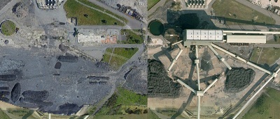
Image 2 is a picture a comparison between what Google Earth shows Harworth Colliery to look like (right) and what is actually looks like (left).
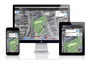
Image 3 is a picture of the OcuVue platform which is a part of the Aerial Map Market system.